This land is the sweet spot of the Kootenays!
It is located halfway between East Kootenays and West Kootenays. The convenient location is perfect for enjoying all that the Kootenays has to offer while living in the sweetest place.
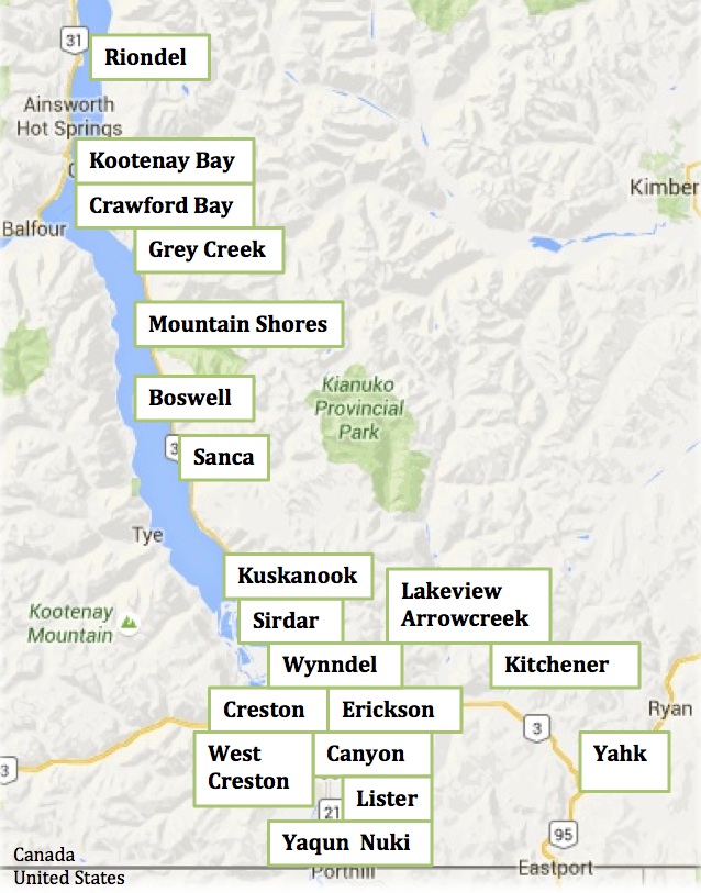
Our communities are all within the Regional District of Central Kootenay (RDCK) regional boundaries and are often grouped as Areas A, B, C and Creston.
The combined population is 13,172.
2016 Census Stats for the Kootenays.
The locals refer to the communities on the east shore of the Kootenay Lake, from Kuskanook to Riondel, as one large community called East Shore. The other communities in this area are referred to as Creston Valley, except for Kitchener and Yahk.
It is worthwhile noting that the Creston Valley and East Shore do not switch over to “Daylight Savings Time.” This area always stays at the same time year-round.
The average drive time to these neighbourhoods from Creston is about 10 minutes, except Kitchener is approx. 15 minutes east on Highway 3, and Yahk is about 30 minutes east. Heading north on Highway 3A takes you to Boswell in approx. 30 minutes, Crawford Bay in 45 minutes, and Kootenay Bay/Riondel about 60+ minutes depending on seasonal traffic.
Each one of these neighbourhoods has its unique character and qualities that are influenced by their history, geography, and rural living. Our people naturally learn to be resourceful and collaborative.

All the communities
Town of Creston

West Creston – Area C
This community is a short 10-minute drive from Creston. The West Creston Hall is a hub of activity. West Creston provides excellent opportunities to spot wildlife and to birdwatch throughout the Creston Valley Wildlife Management Area. This area also includes some fantastic walks through the wetlands and channels. West Creston is also known for flatwater canoeing or kayaking.
South of Creston
Lister – Area B
East of Creston
Erickson – Area B
Kitchener – Area B
Canyon - Area B
Canyon is a farming community about 10 minutes drive east of Creston. When the people of the Creston Valley think of Canyon, they likely think of fly-fishing on the Goat River or orchards or horses. Historically Canyon Park hosted Chuckwagon or Chariot Races during the Blossom Festival weekend. Now the grounds is mainly used by the 4H Club and Creston and District Community Complex programs, and the campground for special events. Residents are fond of their community hall, school and convenience
store.
Yahk and Kingsgate – Area B
Yahk is a 30-minute drive from Creston along Hwy 3. Outdoor recreationists and individualists are attracted to live here. This friendly community cherishes its beautiful Hall. There are a couple of convenience stores with fuel, touristy stores, and 3 RV parks. The Yahk Provincial Camp Ground is conveniently located just off the highway and along the Moyie River.
Lakeview Arrow Creek – Area B
North of Creston is the East Shore – Area A
Wynndel
Boswell
Boswell is a stretch of area that follows the Kootenay Lake shoreline on Highway 3. The active Boswell Hall is a short 30-minute drive from Creston. Local recreationists, especially fisher-persons, make good use of the Boswell Boat Ramp.
Most of the housing is along the lake. There are a few communities within Boswell, such as Twin Bays, Sanca, and Destiny Bay, with its convenience store. Mountain Shores Resort is another community within Boswell. This gated community makes rural living look easy (they even have their marina with fuel).
Gray Creek
Today there are many seasonal residents in Gray Creek who make this beautiful location along Hwy 3A their “home away from home.” A visit to the historical Gray Creek Store tells tales of life here from 1913 on; it is an excellent source for local knowledge and household goods.
Crawford Bay
Crawford Bay is an eclectic community located on the Kootenay Lake 60-minute drive from Creston. Each summer, tourists arrive to meander through the shops within the artist community. It has seasonal restaurants, a year-round convenience store, and a K to 12 school. There is a public beach in the bay within walking distance of the campgrounds. Located within the community is one of BC’s most scenic golf courses, Kokanee Springs. This area is becoming known for mountain biking. A local trail map makes it easy for newcomers to get out on the trails, either on foot or on a bike.
Kootenay Bay
This area is around the corner from Crawford Bay. The world’s longest free ferry ride (30 minutes) takes you over to the other side of the lake to the community of Balfour. There is a public boat launch near the ferry landing. A short drive along Pilot Point will take you to Pilot Point trailhead. This trail follows along the lake and gives you access by foot to a provincial marine park and other beaches. A little further down the road is a trailhead to a historical lighthouse where you can enjoy a fantastic view of the lake.
Riondel
Riondel is a town located on the Kootenay Lake at the end of the lake road. Riondel’s history goes back to 1882 when it became a booming mining town until the Bluebell Mine closed in 1972. Now it is a haven for retirees and mobile workers. This little town has a fire department, grocery store, restaurant pub, internet service, and community center with curling rink. It has an active community that includes the performing arts. Within its town limits is a beautiful park along the lake with camping facilities. Summer tourists provide a welcome change of pace for full-time local residents. The Riondel Golf course is enjoyed by those who don’t take the game too seriously and enjoy life as it comes. The Yasodhara Ashram, a yoga retreat and study centre is a special place to visit whether to partake in one of their programs or to drop by for a short visit.

